Picture stepping off your deck and onto the water at first light. Buying on the water in Hampton Bays can deliver that daily calm, but it also adds layers of permits, flood rules, and boating realities that shape value and use. If you want smooth sailing from accepted offer to first launch, a little local due diligence goes a long way. In this guide, you will learn how water type changes value, which permits you may need, what flood maps mean for insurance, and how to plan for dockage and upkeep. Let’s dive in.
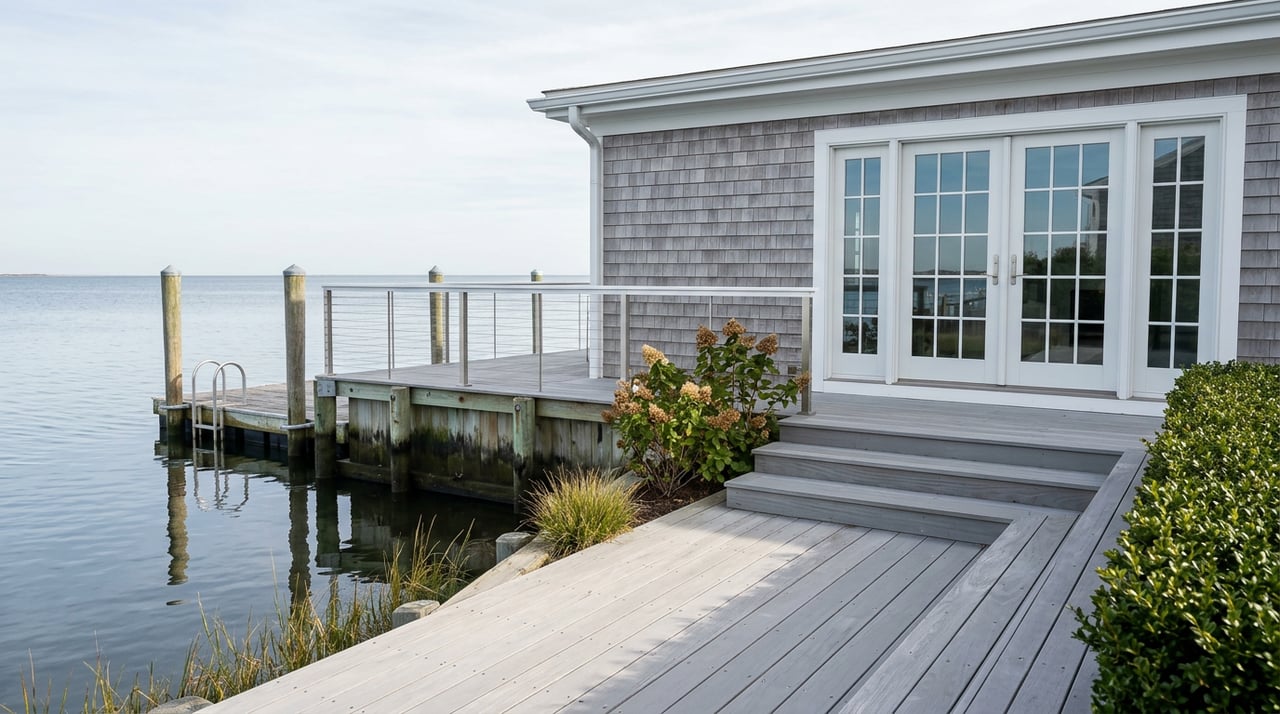
Waterfront types in Hampton Bays
Not all “waterfront” is the same here. Each frontage type carries different access, exposure, and permitting considerations.
- Bayfront on Shinnecock Bay: Often direct frontage with potential for private docks or moorings. Some locations face more open-bay wave action. Always review current FEMA coastal designations like VE and LiMWA when you evaluate buildability and insurance. You can look up any address on the FEMA Flood Map Service Center.
- Canalfront and creekfront: Typically more sheltered, with easier small-boat access. Depths can be limited in some canals and may require maintenance over time. Seasonal conditions can affect draft. Local marinas are useful checkpoints when evaluating actual depths.
- Ponds and tidal creeks: Great for kayaks and small runabouts. Navigation for deeper-draft boats is often limited. Confirm any mooring or dock rules with the Town Trustees before you assume a structure is allowed.
For every property, match the frontage type to your intended use. A sheltered canal may be perfect for a center console, while an exposed bayfront might command a premium for views but require more robust shoreline protection.
Boating access and tides
Depth and draft planning
Tidal range and timing matter when you rely on a private dock or shallow canal. NOAA benchmark data for Ponquogue Point near the Shinnecock approach provides local tidal datums you can use to translate charted depths to real-world water under your keel. For example, Mean Higher High Water and other local datums at Ponquogue help you plan arrivals at high or slack tide if your draft is marginal. Review the latest figures on the NOAA Ponquogue Point benchmark page at NOAA’s tides and currents site.
Inlet conditions and marinas
Shinnecock Inlet is dynamic. Shoaling and currents can limit safe offshore access for some boats at low tide. Confirm channel depths with local marinas and navigation charts before counting on quick ocean access. For slip availability, pump-outs, and transient options, check the local listings on Dockwa for Ponquogue Marina and call early in the season.
Permits and approvals
Town Trustees: docks, moorings, and structures
In Hampton Bays, moorings, docks, and bulkheads in Town waters are regulated by the Southampton Town Trustees. Written Trustee permission is required before placing moorings or structures, and many mooring permits are limited to residents or taxpayers. Rules also set seasonal removal dates, equipment types, and vessel-size limits in specified waterways. Review the Trustees’ code and applications and confirm whether a parcel has any recorded Trustee docking privileges. Trustee approval is separate from a building permit.
State and federal reviews
Many waterfront projects also trigger New York State and federal oversight. NYSDEC typically reviews docks, piers, bulkheads, dredging, and work in or adjacent to tidal wetlands under Article 25 and navigable-waters rules under Article 15. Start with the DEC’s overview of waterways, coastlines, and wetlands permits. Larger or in-water projects often require federal review through the U.S. Army Corps of Engineers. Learn how federal permitting works on the Army Corps Regulatory Program page. Coordination among Trustees, DEC, and the Corps is common.
Timelines and expectations
- Small repairs or PWC floats may be handled with Trustee approval and, in some cases, a DEC general permit.
- Bulkhead replacement, dredging, or new marina slips typically require multi-agency review and can take months, especially if public notices are involved.
Build time for permitting into your plans, and ask the seller for prior permit files to understand what exists and what may be grandfathered.
Flood maps and insurance
How to check your flood zone
Flood risk affects mortgage requirements, insurance costs, and construction standards. Enter the exact property address on FEMA’s Flood Map Service Center to review the effective panel, flood zone (AE, VE, AO, X), and Base Flood Elevation. Newer coastal mapping features like the Limit of Moderate Wave Action can change where elevated construction is required.
Insurance basics and lender rules
If a home is in a Special Flood Hazard Area and you use a regulated lender, flood insurance is typically required. Under the NFIP, single-family building coverage tops out at $250,000 with contents up to $100,000. FEMA’s Risk Rating 2.0 prices policies based on property-specific factors like distance to water, first-floor elevation, and replacement cost, so premiums can differ widely. For lender requirements and acceptance of private flood policies, review the Interagency Q&A on flood insurance from the Federal Reserve. Get NFIP and private-market quotes early to compare options.
Elevation certificates and local standards
An Elevation Certificate from a licensed surveyor often helps price flood insurance accurately and is vital if you plan elevation or renovation work. Learn what it documents on this Elevation Certificate FAQ. Expect separate wind or hurricane deductibles on coastal homeowner policies in New York. For a quick primer on flood insurance costs and coverage basics, see this consumer guide on homeowners and flood insurance costs.
Dockage and upkeep
Moorings vs docks vs marina slips
Trustee mooring permits are typically resident-based, with rules on marking, seasonal removal, and boat sizes in specific creeks and ponds. Confirm what your parcel can legally host, and do not assume that an existing float or ramp is permitted. Review the Trustees’ code and applications and contact local marinas early via Dockwa listings if you need a seasonal slip.
Dredging and depth tradeoffs
Some canalfront lots sit on shallow channels that may need periodic dredging to maintain access. Dredging often triggers DEC and Army Corps review, and scheduling can affect your boating season. Check past permits and talk with neighbors about maintenance history before you count on deep-draft access.
Budget for shoreline maintenance
Waterfront ownership can come with cyclical costs. Bulkhead or seawall repair and replacement can be significant, depending on length and complexity. Plan for dock replacement over time, pile repair, seasonal float haul-out, and boat storage and insurance. Ask the seller for recent maintenance records and any obligations noted in Trustee or permit files.
Water quality and septic
Shinnecock Bay and nearby waters have experienced episodic algal blooms, including brown tide, which can affect clarity and shellfishing. Local efforts target nitrogen reduction from older septic systems, and upgrades may be encouraged or required for renovations in sensitive areas. For context on bloom activity in the region, see local reporting on brown tide in western Shinnecock and Quantuck Bays. When you evaluate a home, ask for septic inspection records and consider whether future upgrades could be part of your plans.
Market snapshot and value drivers
As of March 3, 2026, a recent snapshot placed the median list price for Hampton Bays waterfront homes near $1.25M. Actual value varies widely by frontage, dockage, elevation, and condition. In broad strokes:
- Entry-level waterfront, such as select canal condos or small bungalows, can appear in the mid-six-figure range when available.
- Mid-tier canal and bayfront single-family homes with limited deep-water access often trade in the $1M to $3M range.
- Upper-tier bayfront with direct deep-water access or larger renovated properties can command several million dollars.
Treat these as ranges only. Live comps and a property-specific valuation will give you the most reliable picture. Dock usability, flood zone and projected insurance, and any septic or permitting constraints are among the biggest value drivers.
Due diligence checklist
Use this quick list to organize your offer and inspection period.
- Flood and elevation
- Look up the exact address on FEMA’s Flood Map Service Center for zone and Base Flood Elevation.
- Request any Elevation Certificate or recent survey. If none exists, plan to order one.
- Docks, moorings, and permits
- Review the Southampton Town Trustees code and forms. Confirm mooring eligibility and any recorded dock privileges or easements.
- Ask for copies of prior NYSDEC and Army Corps permits for docks, bulkheads, or dredging.
- Insurance and lending
- Get NFIP and at least one private-market flood quote sized to the home’s replacement cost. Confirm your lender’s acceptance of private flood where applicable. The Federal Reserve Q&A is a helpful reference.
- Boating and access
- Confirm depths with local marinas and review NOAA tidal datums for planning. The Ponquogue benchmark is on NOAA’s data page. Check Dockwa for slip leads and waitlists.
- Septic and water quality
- Request septic inspection records. Ask about nearby water-quality advisories or closures, and review recent local reporting like the brown tide coverage.
Next steps
Buying on the water in Hampton Bays rewards careful planning. Match the frontage to your boating goals, verify permit history and flood data early, and price insurance and maintenance into your budget. If you want a precise read on value and risk, lean on local expertise that pairs brokerage with certified appraisal insight. To discuss a specific property or request a valuation, reach out to Jennifer McLauchlen for a confidential consultation.
FAQs
Can I install a dock or mooring on a Hampton Bays property?
- Start with the Southampton Town Trustees. Written Trustee permission governs moorings and structures in Town waters, and many moorings are resident-limited. Review the Trustees’ code and confirm any recorded docking rights.
How do I check if a Hampton Bays home is in a flood zone?
- Enter the exact address on FEMA’s Flood Map Service Center to see the effective panel, flood zone, and Base Flood Elevation that may drive insurance and building requirements.
What flood insurance will my lender require for a waterfront home?
- If the home is in a Special Flood Hazard Area and you finance with a regulated lender, flood insurance is typically required. Learn lender rules and private flood acceptance in the Interagency Q&A.
How do tides and inlet conditions affect boat size and usage?
- Tidal range and inlet shoaling affect safe draft and timing. Use local datums at Ponquogue on NOAA’s tides site and confirm current depths with marinas before relying on a private dock for larger boats.
What affects water quality in Shinnecock Bay and nearby creeks?
- Episodic algal blooms like brown tide and nitrogen from legacy septic systems influence clarity and shellfishing. See local reporting on brown tide activity and ask for recent water-quality updates during due diligence.